Using Maps to Teach History
I like to use physical two-dimensional maps with students. I think they can be very useful to show the movements and changes in a place like the United States that has changed quite a bit since Europeans began coming en masse since the 1500s.
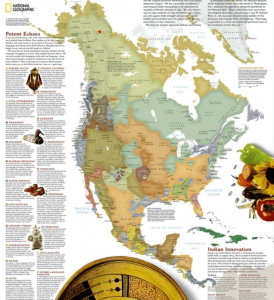
I recently used his map from National Geographic in my third grade class. There are a number of maps overlaying Native American groups (by tribe, language, culture, etc.) that have started to appear online in the last few years. My students’ textbooks have a California map similar to this one.
The problem with showing a map with political boundaries (the present day California) rather than the whole continent is that it centers the current day boundaries, which are often arbitrary. What I talked about with my students was how these tribes and groups did not stop at the present-day border. Next week they will be studying about the Kumeyaay, a tribe with members on both sides of the California and Mexico border. We also discussed the Yurok, who have a very different lifestyle, etc. and have a lot more in common with tribes going up along the coast now in Oregon. I want them to think out side these borders, and understand they don’t have much to do with how these groups lived for millennia before Europeans invaded.
Image source: North American Indian Cultures Wall Map from National Geographic